Yuquot (Friendly Cove) Today
By Ian Kennedy / courtesay of Nootka Sound Service
A trip to Friendly Cove puts visitors in touch with British Columbia’s earliest history, with many of its “firsts” — first European contact; first beer brewed in BC; first European inhabitants; first ship built; first visit by a European woman; first European settlement; first gardens… and all at or near British Columbia’s first national historic site, established in 1923.
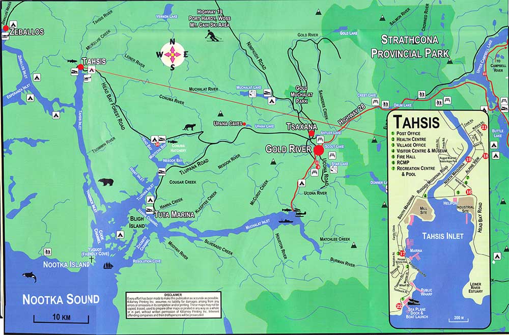
It all starts with a leisurely day-long cruise aboard the MV Uchuck III, leaving Gold River on Wednesdays or Saturdays between June and September. The Uchuck III serves as both a passenger vessel and a working freighter which carries all manner of cargo and people to logging shows and fish camps, fish farms, and settlements along the way. Prepare yourself for interesting stops at which you’ll begin to acquire a feel for something of life on this west coast. Enjoy a muffin, sip a coffee, meet fellow travelers, and then settle down to take in the sights and sounds of the coast: the steep sides of Muchalat Inlet, a U-shaped fiord a remnant of the last ice-age – covered with Douglas Firs, Sitka spruce, Arbutus, Western red and yellow cedar, and Western hemlock. Most of the trees are second growth, but their predecessors might have been upwards of 300 feet high. One Douglas Fir at Woss Lake on northern Vancouver Island grew to 305 feet and had an 18-foot diameter, holding the official record as the largest tree ever cut in British Columbia. Over 1200 years old, it would have been growing before the Vikings invaded Britain.
Imagine the human activity of a few hundreds of years ago when at nearly  every creek mouth along this inlet the Muchalaht people could be found at their summer camps catching and curing salmon for winter food. While doing so, however, they would have been very vigilant, concerned about enemy raiding parties looking to capture slaves. Wars were not uncommon, especially against the neighbouring Mowachaht who, in 1935, despite earlier animosity, amalgamated with the Muchalahts to form one tribe. Along the way you’ll see how modern fishers entice different varieties of salmon onto their lines, the most prized being the Spring or King salmon reaching up to 50 or 60 pounds.
At the mouth of Muchalaht Inlet the MV Uchuck III steers west into Zuciarte – not a Spanish name but a corruption of the name of one of the Muchalaht First Nations band – the Channel between Bligh Island and the mainland, the island named after William Bligh of Mutiny on the Bounty fame but at that time Cook’s navigator on the Resolution. Once past Bligh Island and as the Uchuck III heads across the mouth of Nootka Sound to Nootka Island, look back on the starboard and into Bligh Island’s Resolution Cove, originally called Ship Cove by Captain Cook.
Battered by savage storms on their voyage from Hawaii and seeking a place to make repairs and to find fresh water, Captain James Cook with his ships Resolution and Discovery, limped into this bay on March 29,1778. While the British anchored their ‘floating islands,’ the First Nations people shouted from their canoes: “itchme nutka, itchme nutka,” meaning “go around, go round” to a better anchorage at Yuqout, but Cook misinterpreted their shouts, believing they were calling out Nootka as the name of the area. Despite this initial misunderstanding, he and his men stayed for more than a month here, becoming the first documented Europeans to set foot in British Columbia.
After repairing ships’ masts and spars with Douglas fir wood; brewing beer using Sitka spruce needles, hops and molasses; and trading metal objects for sea otter skins, they sailed for home by way of Alaska and Asia.
In China, they made a small fortune selling the luxurious sea otter pelts acquired at Nootka and, when news of this new source of trade reached others, European and North American traders converged on Nootka — three hundred thirty ships between 1785 and 1825 – and nearly exterminated the sea otter on this coast. Two plaques in the cove commemorate Cook’s visit.
As the Uchuck I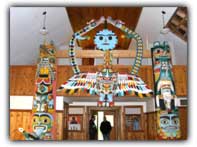 II enters Friendly Cove or Yuquot — “where the wind blows in all directions” – notice the 100-foot high lighthouse on the port side, where the Spanish fort once defended the cove. Built in 1911, the lighthouse is not open to visitors; however, a hike up to it offers a spectacular view of up to sixteen miles visibility up and down the coast — on a clear day, that is. Only two houses now occupy the cove where once stood up to twenty longhouses and where once lived 1500 indigenous people: the summer home of Chief Maquinna and his Nuu-chah-nulth people. Only two now live here, year round.
Once ashore take the path from the end of the pier to the gleaming, white Roman Catholic Church built in 1956 to replace the one built by Father Brabant in 1889, which burned in 1954. The church now serves as a cultural centre and museum. Inside, the two stained glass windows donated by the Spanish Government commemorates the Spanish fort settlement of San Miguel with its extensive gardens that existed at Yuquot from 1789 until 1795. Instead of altar and pulpit now stand two striking and colourful interior houseposts with another two on either side of the archway entrance.
In the choir loft, if not out on loan to other museums, are thirty or so photo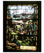 graphic reproductions of the drawings of Thomas de Suria and Jose Cardero done while the two were in Yuquot in the late 1700s and donated in 2002 by the Spanish government. The originals remain in Barcelona.
Outside, and adjacent to the church, the baseball field marks the location of the Spanish gardens where, every August, the Mowachaht-Muchalaht hold their salmon barbecue and Summerfest.
Walk behind the church down to the pebble beach to the West, pass the modern graveyard and go inland to Aa-aak-quaksius Lake or Jewitt lake. A small wooded islet in this lake once housed the Whaler’s Shrine at which the Mowachaht/Muchalaht conducted purification rituals before going whaling, rituals so secret even John Jewitt, a slave of Maquinna in 1803-’04, did not know of the shrine’s existence. Its 92 carved wooden figures, sixteen skulls and the shelter that once protected them currently resides in the American Museum of Natural History in New York, sold to it in 1904. Near the lake, six cabins can be rented.
Head back toward Yuquot, and seek out the large totem pole flat on the ground at the eastern end of Friendly Cove. Erected in 1929 it fell to high winds in 1994. Farther east sits a small cove with a beach where John Meares built the forty-ton North West America in 1778, the first European-style ship launched in B.C.